Strand, London
Major thoroughfare in the City of Westminster, London, EnglandThe Strand is a major street in the City of Westminster, Central London. The street, which is part of London's West End theatreland, runs just over 3⁄4 mile (1.2 km) from Trafalgar Square eastwards to Temple Bar, where it becomes Fleet Street in the City of London, and is part of the A4, a main road running west from central London.
Read article

.jpg)


.svg)

Top Questions
AI generatedMore questions
Nearby Places
Live! (Bob Marley and the Wailers album)
1975 live album by Bob Marley and the Wailers

Lyceum Theatre, London
West End theatre in London
Humanitarian Futures Programme

One Aldwych
Hotel in London
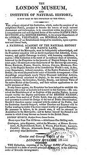
London Museum and Institute of Natural History
Museum in London from 1807 to 1817

Burleigh House, Westminster
Historic building in England

India Club, London
Social club in London, England

Aldwych bus bombing
1996 IRA attack in London, England